Geolocate

Gould topographic map

Click on the map to display elevation.

About this map

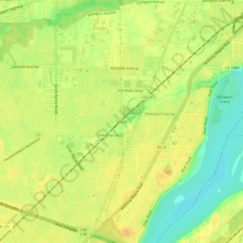
Name: Gould topographic map, elevation, terrain.

Location: Gould, Toledo, Lucas County, Ohio, 43614, United States (41.58338 -83.63132 41.62338 -83.59132)

Average elevation: 190 m

Minimum elevation: 171 m

Maximum elevation: 200 m

Other topographic maps

Click on a map to view its topography, its elevation and its terrain.

Ottawa Park

United States > Ohio > Lucas County > Toledo

Average elevation: 189 m

Gear up for your next adventure:

🥾Trail Hiking Boots - Supportive boots for rough trails
🧢Sun Hat - Wide-brim hat for sun protection
🛰️Satellite Messenger - Emergency communication for areas with no cell service
🥾Trail Hiking Shoes - Durable shoes designed for rugged trails
🧣Evaporative Cooling Towel - Beat the heat during intense summer climbs

As an Amazon Associate, this site earns from qualifying purchases at no extra cost to you.