
Make a donation
Gear up for your next adventure:
As an Amazon Associate, this site earns from qualifying purchases at no extra cost to you.
Allersberg topographic map
Click on the map to display elevation.
Make a donation
Gear up for your next adventure:
As an Amazon Associate, this site earns from qualifying purchases at no extra cost to you.
Allersberg
Im Jahre 2014 gab es in der Gemeinde 1718 sozialversicherungspflichtige Arbeitsplätze. 3266 Einwohner standen in einem versicherungspflichtigen Beschäftigungsverhältnis, so dass die Zahl der Auspendler um 1555 Personen höher war als die der Einpendler. Im Jahre 2010 bestanden 75 landwirtschaftliche Betriebe mit einer landwirtschaftlich genutzten Fläche von 1910 Hektar. Davon waren 987 Hektar Ackerfläche und 914 Hektar Wiesen und Weiden.
Make a donation
Gear up for your next adventure:
As an Amazon Associate, this site earns from qualifying purchases at no extra cost to you.
About this map
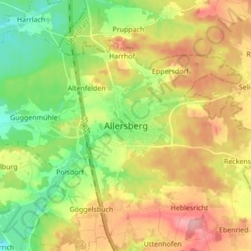
Name: Allersberg topographic map, elevation, terrain.
Location: Allersberg, Landkreis Roth, Bayern, 90584, Deutschland (49.21130 11.19568 49.29130 11.27568)
Average elevation: 408 m
Minimum elevation: 355 m
Maximum elevation: 472 m
Make a donation
Gear up for your next adventure:
As an Amazon Associate, this site earns from qualifying purchases at no extra cost to you.