
Thank you for supporting this site ❤️
Make a donation
Make a donation
Gear up for your next adventure:
As an Amazon Associate, this site earns from qualifying purchases at no extra cost to you.
Huamboy topographic map
Click on the map to display elevation.
Thank you for supporting this site ❤️
Make a donation
Make a donation
Gear up for your next adventure:
As an Amazon Associate, this site earns from qualifying purchases at no extra cost to you.
About this map
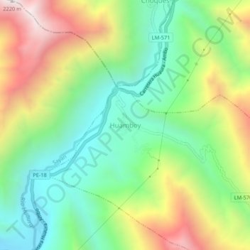
Name: Huamboy topographic map, elevation, terrain.
Location: Huamboy, Leoncio Prado, Huaura, Lima, Perú (-11.04214 -77.10283 -11.00214 -77.06283)
Average elevation: 1,457 m
Minimum elevation: 973 m
Maximum elevation: 2,233 m
Thank you for supporting this site ❤️
Make a donation
Make a donation
Gear up for your next adventure:
As an Amazon Associate, this site earns from qualifying purchases at no extra cost to you.