Geolocate

Reims topographic map

Click on the map to display elevation.

About this map

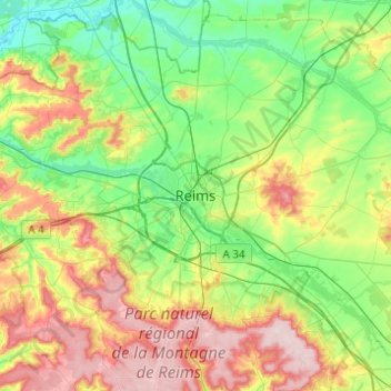
Name: Reims topographic map, elevation, terrain.

Location: Reims, Marne, Grand Est, Metropolitan France, 51100, France (49.09779 3.87193 49.41779 4.19193)

Average elevation: 130 m

Minimum elevation: 49 m

Maximum elevation: 292 m

Gear up for your next adventure:

🛶Kayak Dry Bag - Waterproof storage for kayaking adventures
🥾Durable Hiking Shoes - Long-lasting shoes for frequent hiking
🧭GPS Outdoor Watch - Smart watch for navigation and fitness tracking in nature
🪜Heavy Duty Carabiners - Multi-use clips for securing gear to your backpack
Lightweight Backpacking Tent - Compact tent for efficient hiking trips

As an Amazon Associate, this site earns from qualifying purchases at no extra cost to you.