
Chatsworth topographic map
Click on the map to display elevation.
About this map
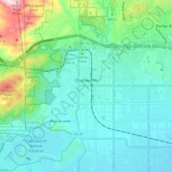
Name: Chatsworth topographic map, elevation, terrain.
Average elevation: 361 m
Minimum elevation: 246 m
Maximum elevation: 818 m
Other topographic maps
Click on a map to view its topography, its elevation and its terrain.
Santa Ynez Reservoir
United States > California > Los Angeles County > Los Angeles
Average elevation: 307 m
Mount Lukens
United States > California > Los Angeles County > Los Angeles
It is in the Sunland-Tujunga community within the northeast corner of the city of Los Angeles, above the Crescenta Valley. The summit, at 5,075 feet (1,547 m) in elevation, is the highest point within the city limits. The summit's elevation makes Los Angeles the city with the largest difference between high…
Average elevation: 1,176 m
Thenard
United States > California > Los Angeles County > Los Angeles > Thenard
Average elevation: 8 m
Los Angeles River
United States > California > Los Angeles County > Los Angeles
Average elevation: 243 m
Mission Junction
United States > California > Los Angeles County > Los Angeles
Average elevation: 103 m
Augustus F. Hawkins Natural Park
United States > California > Los Angeles County > Los Angeles
Average elevation: 55 m
Genesee Avenue Park
United States > California > Los Angeles County > Los Angeles
Average elevation: 33 m