Geolocate

Córdoba topographic map

Click on the map to display elevation.

About this map

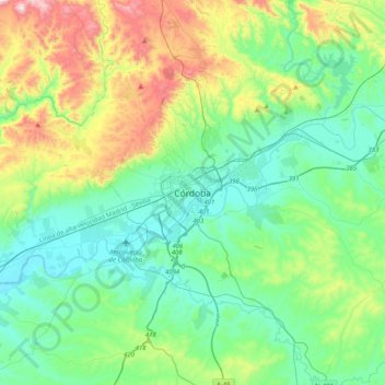
Name: Córdoba topographic map, elevation, terrain.

Location: Córdoba, Cordova, Andalusia, 14002, Spain (37.72458 -4.93601 38.04458 -4.61601)

Average elevation: 262 m

Minimum elevation: 73 m

Maximum elevation: 816 m

Gear up for your next adventure:

🧴Waterproofing Spray - Restore the DWR coating on jackets and tents
🐕Hiking Dog Pack - Let your canine companion carry their own water and food
🧥Waterproof Hiking Jacket - Protect yourself from rain and wind while hiking
🔦UV Flashlight - Detect minerals or specific insects in the dark
🥾Trail Hiking Boots - Supportive boots for rough trails

As an Amazon Associate, this site earns from qualifying purchases at no extra cost to you.