Geolocate

Gleyzin topographic map

Click on the map to display elevation.

About this map

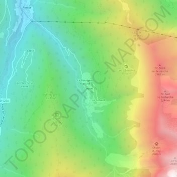
Name: Gleyzin topographic map, elevation, terrain.

Location: Gleyzin, Pinsot, Le Haut-Bréda, Grenoble, Isère, Auvergne-Rhône-Alpes, France métropolitaine, 38580, France (45.31877 6.09979 45.35877 6.13979)

Average elevation: 1,401 m

Minimum elevation: 705 m

Maximum elevation: 2,538 m

Other topographic maps

Click on a map to view its topography, its elevation and its terrain.

Pinsot

France > Auvergne-Rhône-Alpes > Isère > Le Haut-Bréda

La commune de Pinsot est située au creux de la vallée du Haut Bréda dans la chaîne de Belledonne, au pied du massif du Gleyzin (2 600 m) et proche de celui des Sept Laux. Le village est situé au confluent des torrents du Bréda, du Gleyzin et du Jalon. Son altitude est de 732 mètres au niveau de…

Average elevation: 1,522 m

38580

France > Auvergne-Rhône-Alpes > Isère > Le Haut-Bréda > Le Cohard

Average elevation: 1,541 m

Gear up for your next adventure:

🧦Outdoor Socks - Durable socks designed for hiking and outdoor sports
🧥Packable Rain Jacket - Breathable waterproof layer for unpredictable weather
🧭GPS Outdoor Watch - Smart watch for navigation and fitness tracking in nature
🎒Fully Waterproof Backpack - Total protection for photography gear and electronics
Camping Groundsheet - Protect your tent from moisture and dirt

As an Amazon Associate, this site earns from qualifying purchases at no extra cost to you.