Geolocate

Dhubri topographic map

Click on the map to display elevation.

About this map

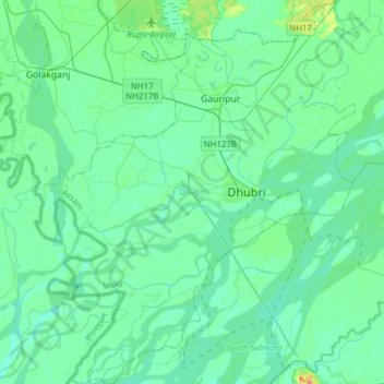
Name: Dhubri topographic map, elevation, terrain.

Location: Dhubri, Assam, India (25.87907 89.81486 26.15758 90.07817)

Average elevation: 28 m

Minimum elevation: 17 m

Maximum elevation: 87 m

Gear up for your next adventure:

🧊Insulated Water Bottle - Keeps drinks cold in summer and prevents freezing in winter
🥾Approach Shoes - Shoes designed for climbing approaches and rugged trails
🥾Trail Hiking Boots - Supportive boots for rough trails
🧴First Aid Kit - Essential first aid supplies for outdoor emergencies
🥾Hiking Shorts - Breathable shorts suitable for summer hikes

As an Amazon Associate, this site earns from qualifying purchases at no extra cost to you.