
Thank you for supporting this site ❤️
Make a donation
Make a donation
Gear up for your next adventure:
As an Amazon Associate, this site earns from qualifying purchases at no extra cost to you.
Brunsbüttel topographic map
Click on the map to display elevation.
Thank you for supporting this site ❤️
Make a donation
Make a donation
Gear up for your next adventure:
As an Amazon Associate, this site earns from qualifying purchases at no extra cost to you.
About this map
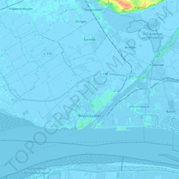
Name: Brunsbüttel topographic map, elevation, terrain.
Location: Brunsbüttel, Kreis Dithmarschen, Schleswig-Holstein, Germany (53.87754 9.01790 53.95062 9.21447)
Average elevation: 0 m
Minimum elevation: -6 m
Maximum elevation: 35 m
Thank you for supporting this site ❤️
Make a donation
Make a donation
Gear up for your next adventure:
As an Amazon Associate, this site earns from qualifying purchases at no extra cost to you.
Other topographic maps
Click on a map to view its topography, its elevation and its terrain.
Alter Meldorfer Hafen
Germany > Schleswig-Holstein > Kreis Dithmarschen > Meldorf
Average elevation: 2 m