
Make a donation
Gear up for your next adventure:
As an Amazon Associate, this site earns from qualifying purchases at no extra cost to you.
Geroldsau topographic map
Click on the map to display elevation.
Make a donation
Gear up for your next adventure:
As an Amazon Associate, this site earns from qualifying purchases at no extra cost to you.
About this map
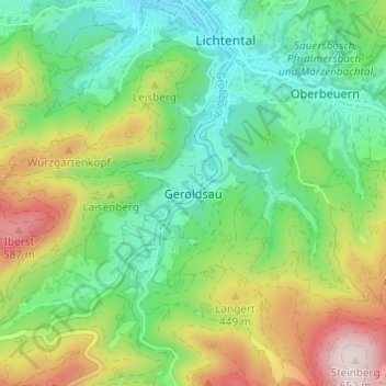
Name: Geroldsau topographic map, elevation, terrain.
Location: Geroldsau, Baden-Baden, Baden-Württemberg, 76530, Deutschland (48.70997 8.23317 48.74997 8.27317)
Average elevation: 338 m
Minimum elevation: 172 m
Maximum elevation: 648 m
Make a donation
Gear up for your next adventure:
As an Amazon Associate, this site earns from qualifying purchases at no extra cost to you.
Other topographic maps
Click on a map to view its topography, its elevation and its terrain.
Altes Schloss
Deutschland > Baden-Württemberg > Baden-Baden
Eine große Windharfe steht in den Ruinen des Rittersaals des Alten Schlosses. Die 1999 aufgestellte Harfe hat eine Gesamthöhe von 4,10 Meter und 120 Saiten, sie wurde von dem in der Region ansässigen Musiker und Harfenbauer Rüdiger Oppermann entwickelt und gebaut, der sie als größte Windharfe Europas…
Average elevation: 293 m
Make a donation
Gear up for your next adventure:
As an Amazon Associate, this site earns from qualifying purchases at no extra cost to you.
Neuweier
Deutschland > Baden-Württemberg > Baden-Baden
Das auf 182 m Höhe in der Vorbergzone des Schwarzwalds gelegene Dorf hat 2135 Einwohner und eine Fläche von 606 Hektar. Davon sind 334 ha Wald und 124 ha Rebfläche.
Average elevation: 291 m