Geolocate

Pampulha topographic map

Click on the map to display elevation.

About this map
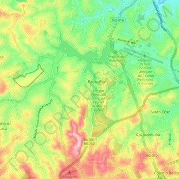
Name: Pampulha topographic map, elevation, terrain.

Location: Pampulha, Belo Horizonte, Minas Gerais, Southeast Region, Brazil (-19.90994 -44.02221 -19.82576 -43.92743)

Average elevation: 835 m

Minimum elevation: 738 m

Maximum elevation: 970 m

Other topographic maps

Click on a map to view its topography, its elevation and its terrain.
Parque Riachuelo

Brazil > Minas Gerais > Belo Horizonte

Average elevation: 854 m

Gear up for your next adventure:

⛺Family Camping Tent - Spacious tent suitable for family camping trips
🥾Durable Hiking Shoes - Long-lasting shoes for frequent hiking
🧥Softshell Jacket - Windproof and breathable jacket for hiking
🧢Hiking Sun Hat - Wide-brimmed protection for exposed mountain ridges
🛁Quick-Dry Microfiber Towel - Space-saving towel that dries rapidly on the move

As an Amazon Associate, this site earns from qualifying purchases at no extra cost to you.