
Enrile topographic map
Click on the map to display elevation.
Enrile
Enrile is bounded by hills and mountains on both North and West. Area with low elevation is about 20 meters above sea level at the Eastern part which lies close to the river boundaries. The highest elevation is found Northwest which is approximately 800 meters above sea level.
About this map
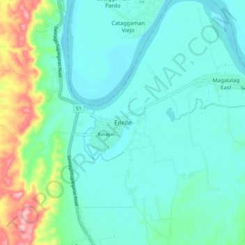
Name: Enrile topographic map, elevation, terrain.
Location: Enrile, Cagayan, Cagayan Valley, Philippines (17.52176 121.66071 17.60176 121.74071)
Average elevation: 45 m
Minimum elevation: 8 m
Maximum elevation: 188 m