
Thank you for supporting this site ❤️
Make a donation
Make a donation
Gear up for your next adventure:
As an Amazon Associate, this site earns from qualifying purchases at no extra cost to you.
Tardam topographic map
Click on the map to display elevation.
Thank you for supporting this site ❤️
Make a donation
Make a donation
Gear up for your next adventure:
As an Amazon Associate, this site earns from qualifying purchases at no extra cost to you.
About this map
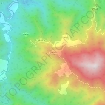
Name: Tardam topographic map, elevation, terrain.
Location: Tardam, Toudja, Daïra El Kseur, Béjaïa, 06030, Algérie (36.77827 4.77959 36.81827 4.81959)
Average elevation: 420 m
Minimum elevation: 83 m
Maximum elevation: 913 m
Thank you for supporting this site ❤️
Make a donation
Make a donation
Gear up for your next adventure:
As an Amazon Associate, this site earns from qualifying purchases at no extra cost to you.