
Make a donation
Gear up for your next adventure:
As an Amazon Associate, this site earns from qualifying purchases at no extra cost to you.
Nemmersdorf topographic map
Click on the map to display elevation.
Make a donation
Gear up for your next adventure:
As an Amazon Associate, this site earns from qualifying purchases at no extra cost to you.
Nemmersdorf
Durch das Pfarrdorf fließt der Saulochbach, ein linker Zufluss der Kronach. Es ist unmittelbar von Acker- und Grünland umgeben und liegt am Westhang eines Höhenzuges des Fichtelgebirges in der Goldkronacher Forst. Die Kreisstraße BT 12 führt an der Ziegelhütte vorbei zur Staatsstraße 2163 bei Goldkronach (1,3 km nördlich) bzw. an Kreuzstein vorbei zur Staatsstraße 2181 bei Untersteinach (2,7 km südlich). Gemeindeverbindungsstraßen führen Die BT 12 kreuzend nach Forthof (0,7 km westlich), ebenfalls die BT 12 kreuzend nach Pöllersdorf (1 km südwestlich), nach Haag (0,7 km nordöstlich) und nach Reuth (0,7 km südöstlich).
Make a donation
Gear up for your next adventure:
As an Amazon Associate, this site earns from qualifying purchases at no extra cost to you.
About this map
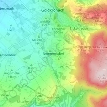
Name: Nemmersdorf topographic map, elevation, terrain.
Average elevation: 510 m
Minimum elevation: 385 m
Maximum elevation: 745 m
Make a donation
Gear up for your next adventure:
As an Amazon Associate, this site earns from qualifying purchases at no extra cost to you.
Other topographic maps
Click on a map to view its topography, its elevation and its terrain.
Fürstenstein
Deutschland > Bayern > Landkreis Bayreuth > Goldkronach > Brandholz > Beerfleck
Average elevation: 621 m