Geolocate

Alpharetta topographic map

Click on the map to display elevation.

About this map

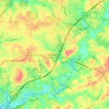
Name: Alpharetta topographic map, elevation, terrain.

Location: Alpharetta, Fulton County, Georgia, 30009, United States (34.03096 -84.31473 34.11096 -84.23473)

Average elevation: 325 m

Minimum elevation: 284 m

Maximum elevation: 373 m

Other topographic maps

Click on a map to view its topography, its elevation and its terrain.

Gear up for your next adventure:

🥾Waterproof Hiking Boots - Boots keeping your feet dry in wet conditions
🧳Compression Sacks - Maximize space in your backpack by shrinking gear
🥾Hiking Shorts - Breathable shorts suitable for summer hikes
🥾Mountaineering Boots - Supportive boots for climbing and high-altitude hiking
🥾Trail Hiking Boots - Supportive boots for rough trails

As an Amazon Associate, this site earns from qualifying purchases at no extra cost to you.