Geolocate

Sirolo topographic map

Click on the map to display elevation.

About this map

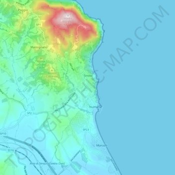
Name: Sirolo topographic map, elevation, terrain.

Location: Sirolo, Ancona, Marche, Italy (43.47915 13.57199 43.55901 13.62842)

Average elevation: 68 m

Minimum elevation: -1 m

Maximum elevation: 567 m

Gear up for your next adventure:

Camping Groundsheet - Protect your tent from moisture and dirt
🥾Light Trekking Boots - Supportive boots for multi-day treks
👟Trail Running Shoes - Agile footwear for fast-paced topographic exploration
🛏️Sleeping Bag - Warm and compact sleeping bags for outdoor camping
🥾Trekking Boots - Durable boots for long-distance trekking

As an Amazon Associate, this site earns from qualifying purchases at no extra cost to you.