
Make a donation
Gear up for your next adventure:
As an Amazon Associate, this site earns from qualifying purchases at no extra cost to you.
Oberursel topographic map
Click on the map to display elevation.
Make a donation
Gear up for your next adventure:
As an Amazon Associate, this site earns from qualifying purchases at no extra cost to you.
Oberursel
Oberursel (Taunus), in früherer Zeit auch Oberorschel geschrieben, ist mit 46.678 Einwohnern (31. Dezember 2020) nach Bad Homburg vor der Höhe die zweitgrößte Stadt im Hochtaunuskreis sowie die dreizehntgrößte in Hessen. Oberursel grenzt unmittelbar an die Stadt Frankfurt am Main.
Make a donation
Gear up for your next adventure:
As an Amazon Associate, this site earns from qualifying purchases at no extra cost to you.
About this map
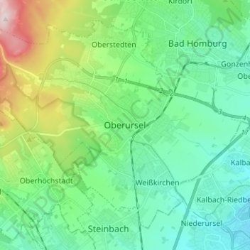
Name: Oberursel topographic map, elevation, terrain.
Location: Oberursel, Hochtaunuskreis, Hessen, 61440, Deutschland (50.16055 8.54045 50.24055 8.62045)
Average elevation: 216 m
Minimum elevation: 110 m
Maximum elevation: 540 m
Make a donation
Gear up for your next adventure:
As an Amazon Associate, this site earns from qualifying purchases at no extra cost to you.