
Make a donation
Gear up for your next adventure:
As an Amazon Associate, this site earns from qualifying purchases at no extra cost to you.
Peña Roya topographic map
Click on the map to display elevation.
Make a donation
Gear up for your next adventure:
As an Amazon Associate, this site earns from qualifying purchases at no extra cost to you.
About this map
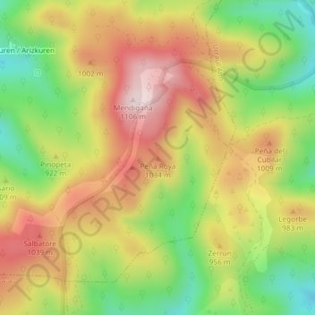
Name: Peña Roya topographic map, elevation, terrain.
Location: Peña Roya, Arce, Prepirineo, España (42.82210 -1.27147 42.82220 -1.27137)
Average elevation: 901 m
Minimum elevation: 700 m
Maximum elevation: 1,094 m
Make a donation
Gear up for your next adventure:
As an Amazon Associate, this site earns from qualifying purchases at no extra cost to you.
Other topographic maps
Click on a map to view its topography, its elevation and its terrain.
Azparren
España > Prepirineo > Arce
La localidad de Azparren está situada en la parte Noroeste del municipio de Arce a una altitud de 920 m s. n. m. Su término concejil tiene una superficie de 10,84 km² y limita al norte con los municipios de Oroz-Betelu y Garayoa; al este con el municipio de Abaurrea Baja y el término de Aristu en el…
Average elevation: 978 m