Geolocate

Lembongan topographic map

Click on the map to display elevation.

About this map

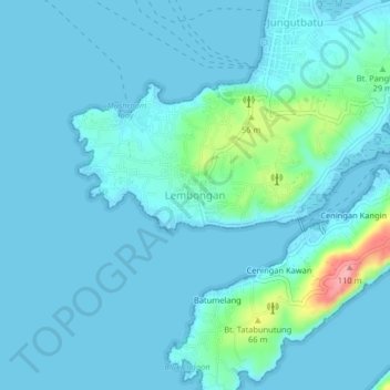
Name: Lembongan topographic map, elevation, terrain.

Location: Lembongan, Jungutbatu, Nusa Penida Subdistrict, Klungkung Regency, Bali, Lesser Sunda Islands, 80372, Indonesia (-8.71089 115.41986 -8.67089 115.45986)

Average elevation: 13 m

Minimum elevation: -1 m

Maximum elevation: 116 m

Other topographic maps

Click on a map to view its topography, its elevation and its terrain.

Gear up for your next adventure:

🛏️Sleeping Bag - Warm and compact sleeping bags for outdoor camping
🧥Softshell Hiking Jacket - The perfect balance of wind protection and breathability
🧰Multitool Knife - Compact and versatile tool for outdoor use
Camping Groundsheet - Protect your tent from moisture and dirt
🥤Collapsible Travel Cup - Saves space and weight in your mess kit

As an Amazon Associate, this site earns from qualifying purchases at no extra cost to you.