Geolocate

Troy topographic map

Click on the map to display elevation.

About this map
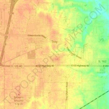
Name: Troy topographic map, elevation, terrain.

Location: Troy, Madison County, Illinois, 62294, United States (38.69798 -89.93313 38.74791 -89.86634)

Average elevation: 166 m

Minimum elevation: 140 m

Maximum elevation: 178 m

Other topographic maps

Click on a map to view its topography, its elevation and its terrain.
North Venice

United States > Illinois > Madison County > Venice

Average elevation: 126 m

North Alton

United States > Illinois > Madison County > Godfrey

Average elevation: 179 m

Bethalto

United States > Illinois > Madison County > Bethalto > Bethalto

Average elevation: 156 m

Gear up for your next adventure:

🍽️Titanium Camping Spork - Ultralight and indestructible eating utensil
🛌Down Sleeping Bag - Superior warmth-to-weight ratio for cold nights
🔨Vehicle Emergency Tool - Safety tool for remote road trips to trailheads
🥾Hiking Gaiters - Protect legs and shoes from mud, snow, and debris
🥾Trail Running Boots - Durable shoes designed for trail running

As an Amazon Associate, this site earns from qualifying purchases at no extra cost to you.