
Make a donation
Gear up for your next adventure:
As an Amazon Associate, this site earns from qualifying purchases at no extra cost to you.
Aver-o-Mar topographic map
Click on the map to display elevation.
Make a donation
Gear up for your next adventure:
As an Amazon Associate, this site earns from qualifying purchases at no extra cost to you.
About this map
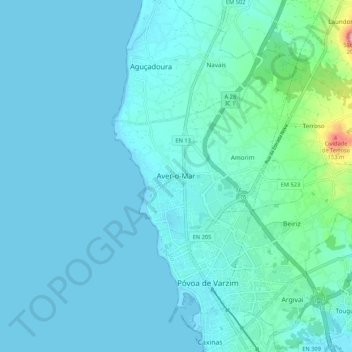
Name: Aver-o-Mar topographic map, elevation, terrain.
Location: Aver-o-Mar, Póvoa de Varzim, Porto, 4490-091, Portugal (41.36375 -8.80953 41.44375 -8.72953)
Average elevation: 18 m
Minimum elevation: -2 m
Maximum elevation: 171 m
Make a donation
Gear up for your next adventure:
As an Amazon Associate, this site earns from qualifying purchases at no extra cost to you.
Other topographic maps
Click on a map to view its topography, its elevation and its terrain.
Make a donation
Gear up for your next adventure:
As an Amazon Associate, this site earns from qualifying purchases at no extra cost to you.
Lago do Parque da Cidade Póvoa de Varzim
Portugal > Porto > Póvoa de Varzim > Amorim
Average elevation: 24 m
Make a donation
Gear up for your next adventure:
As an Amazon Associate, this site earns from qualifying purchases at no extra cost to you.