
Make a donation
Gear up for your next adventure:
As an Amazon Associate, this site earns from qualifying purchases at no extra cost to you.
Tarbat Ness Lighthouse topographic map
Click on the map to display elevation.
Make a donation
Gear up for your next adventure:
As an Amazon Associate, this site earns from qualifying purchases at no extra cost to you.
Tarbat Ness Lighthouse
The Tarbat Ness Lighthouse is located at the North West tip of the Tarbat Ness peninsula near the fishing village of Portmahomack on the east coast of Scotland. It was built in 1830 by Robert Stevenson and has an elevation of 53 metres (174 ft) and 203 steps to the top of the tower.
Make a donation
Gear up for your next adventure:
As an Amazon Associate, this site earns from qualifying purchases at no extra cost to you.
About this map
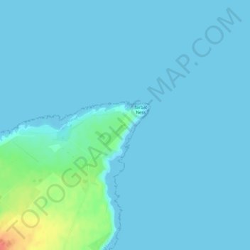
Name: Tarbat Ness Lighthouse topographic map, elevation, terrain.
Average elevation: 5 m
Minimum elevation: 0 m
Maximum elevation: 49 m
Make a donation
Gear up for your next adventure:
As an Amazon Associate, this site earns from qualifying purchases at no extra cost to you.
Other topographic maps
Click on a map to view its topography, its elevation and its terrain.