Geolocate

Fredriksberg topographic map

Click on the map to display elevation.

About this map

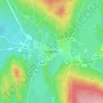
Name: Fredriksberg topographic map, elevation, terrain.

Location: Fredriksberg, Ludvika kommun, Dalarna County, 770 10, Sweden (60.11984 14.35625 60.15984 14.39625)

Average elevation: 322 m

Minimum elevation: 270 m

Maximum elevation: 437 m

Other topographic maps

Click on a map to view its topography, its elevation and its terrain.

Ässån

Sweden > Dalarna County

Average elevation: 184 m

Hedemora kommun

Sweden > Dalarna County

Average elevation: 162 m

Rättviks kommun

Sweden > Dalarna County

Average elevation: 300 m

Malung-Sälens kommun

Sweden > Dalarna County

Average elevation: 395 m

Gear up for your next adventure:

🧭GPS Handheld Device - Reliable GPS navigation for outdoor adventures
🥾Durable Hiking Shoes - Long-lasting shoes for frequent hiking
🧥Thermal Layer - Insulating layer for cold outdoor conditions
💡Portable Camping Lamp - Rechargeable lamp for campsite lighting
🧭GPS Outdoor Watch - Smart watch for navigation and fitness tracking in nature

As an Amazon Associate, this site earns from qualifying purchases at no extra cost to you.