
Make a donation
Gear up for your next adventure:
As an Amazon Associate, this site earns from qualifying purchases at no extra cost to you.
Bernberg topographic map
Click on the map to display elevation.
Make a donation
Gear up for your next adventure:
As an Amazon Associate, this site earns from qualifying purchases at no extra cost to you.
Bernberg
Die Haltestellen ‚Hahnenkroh‘, ‚Bernberg‘ und ‚Altenzentrum‘ werden über die Buslinie 303 (Gummersbach – Eckenhagen / Waldbröl), die Haltestellen ‚Hahnenkroh‘, ‚Großenbernberger Str.‘, ‚Südring Mitte‘, ‚Falkenhöhe‘ und ‚Bernberg‘ auch durch die Buslinie 364 (Rundverkehr Gummersbach – Bernberg) angeschlossen.
Make a donation
Gear up for your next adventure:
As an Amazon Associate, this site earns from qualifying purchases at no extra cost to you.
About this map
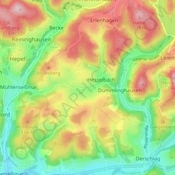
Name: Bernberg topographic map, elevation, terrain.
Average elevation: 284 m
Minimum elevation: 188 m
Maximum elevation: 396 m
Make a donation
Gear up for your next adventure:
As an Amazon Associate, this site earns from qualifying purchases at no extra cost to you.