
Rossel Island topographic map
Interactive map
Click on the map to display elevation.
About this map
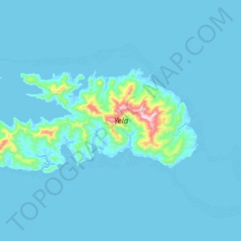
Name: Rossel Island topographic map, elevation, terrain.
Location: Rossel Island, Milne Bay, Papua Region, Papua New Guinea (-11.42469 153.97222 -11.29017 154.28510)
Average elevation: 36 m
Minimum elevation: -3 m
Maximum elevation: 741 m
The highest elevation is Mount Rossel, near the eastern end of the island, which rises 838 metres (2,749 ft). This precipitous peak has steep ridges extending to the north and west, but it descends in more gentle slopes southeast to Cape Deliverance, the eastern end of the island. The southwest ridge has two conspicuous peaks each 549 metres (1,801 ft) high. The eastern peak, Mount Mo, is flat-topped. The western peak is conical. At the western end of the island is a conspicuous conical peak 347 metres (1,138 ft) high.
Other topographic maps
Click on a map to view its topography, its elevation and its terrain.
Guasopa
Guasopa, Milne Bay, Southern Region, Papua New Guinea
Average elevation: 7 m
Sololo
Sololo, Milne Bay, Southern Region, Papua New Guinea
Average elevation: 106 m
Sineada
Papua New Guinea > Milne Bay > Milne Bay District
Sineada, Milne Bay District, Milne Bay, Southern Region, Papua New Guinea
Average elevation: 18 m
Tagula
Tagula, Milne Bay, Southern Region, Papua New Guinea
Average elevation: 14 m
Kiriwina Island
Kiriwina Island, Esa’ala District, Milne Bay, Papua Region, Papua New Guinea
Average elevation: 1 m
Misima Island
Misima Island, Misima District, Milne Bay, Papua Region, Papua New Guinea
Average elevation: 27 m
Mudge Island
Mudge Island, Milne Bay, Southern Region, Papua New Guinea
Average elevation: 1 m
Milne Bay District
Papua New Guinea > Milne Bay > Milne Bay District
Milne Bay District, Milne Bay, Southern Region, Papua New Guinea
Average elevation: 82 m
Woodlark Island
Woodlark Island, Losuia District, Milne Bay, Papua Region, Papua New Guinea
Average elevation: 9 m
Goodenough Island
Goodenough Island, Esa’ala District, Milne Bay, Papua Region, Papua New Guinea
Average elevation: 103 m
Gadogadoa Island
Gadogadoa Island, Milne Bay District, Milne Bay, Papua Region, Papua New Guinea
Average elevation: 10 m
Yeina Island
Yeina Island, Misima District, Milne Bay, Papua Region, Papua New Guinea
Average elevation: 16 m
Halfway Rock
Halfway Rock, Losuia District, Milne Bay, Papua Region, Papua New Guinea
Average elevation: 7 m
D'Entrecasteaux Islands
D'Entrecasteaux Islands, Milne Bay, Southern Region, Papua New Guinea
Average elevation: 76 m
Powell Island
Powell Island, Milne Bay District, Milne Bay, Papua Region, Papua New Guinea
Average elevation: 2 m
Dobu Island
Dobu Island, Esa’ala District, Milne Bay, Papua Region, Papua New Guinea
Average elevation: 81 m
Sideia Island
Sideia Island, Milne Bay District, Milne Bay, Papua Region, Papua New Guinea
Average elevation: 30 m
Fergusson Island
Fergusson Island, Esa’ala District, Milne Bay, Papua Region, Papua New Guinea
Average elevation: 98 m