Geolocate

Bunt topographic map

Click on the map to display elevation.

About this map

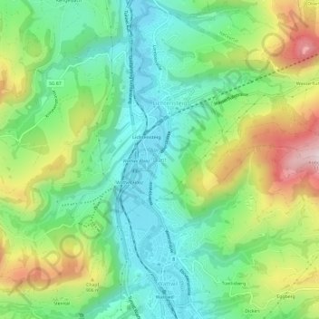
Name: Bunt topographic map, elevation, terrain.

Location: Bunt, Wattwil, Wahlkreis Toggenburg, St. Gallen, 9620, Switzerland (47.29598 9.06563 47.33598 9.10563)

Average elevation: 775 m

Minimum elevation: 593 m

Maximum elevation: 1,118 m

Other topographic maps

Click on a map to view its topography, its elevation and its terrain.

Nesslau

Switzerland > St. Gallen > Wahlkreis Toggenburg

Average elevation: 1,163 m

Wattwil

Switzerland > St. Gallen > Wahlkreis Toggenburg

Average elevation: 853 m

Necker

Switzerland > St. Gallen > Wahlkreis Toggenburg

Average elevation: 861 m

Gear up for your next adventure:

💧Filtered Water Bottle - Safe drinking water on the go
🍽️Titanium Camping Spork - Ultralight and indestructible eating utensil
💡LED Headlamp - Hands-free illumination for night hiking and camping
🧥Thermal Layer - Insulating layer for cold outdoor conditions
🧊Insulated Water Bottle - Keeps drinks cold in summer and prevents freezing in winter

As an Amazon Associate, this site earns from qualifying purchases at no extra cost to you.