Geolocate

Pesisir Bukit topographic map

Click on the map to display elevation.

About this map

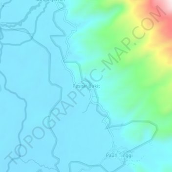
Name: Pesisir Bukit topographic map, elevation, terrain.

Location: Pesisir Bukit, Kerinci, Jambi, Sumatra, Indonesia (-1.75869 101.34802 -1.71869 101.38802)

Average elevation: 1,454 m

Minimum elevation: 1,375 m

Maximum elevation: 1,931 m

Other topographic maps

Click on a map to view its topography, its elevation and its terrain.

Sungai Kuning

Indonesia > Jambi > Kerinci

Average elevation: 1,247 m

Sungai Siulak Deras Kanan

Indonesia > Jambi > Kerinci > Sako Duo

Average elevation: 1,762 m

Gear up for your next adventure:

🧦Hiking Liner Socks - Thin base layer to prevent friction and blisters
🦟Insect Repellent - Keep mosquitoes and black flies away in wooded areas
🥾Approach Shoes - Shoes designed for climbing approaches and rugged trails
🛶Kayak Dry Bag - Waterproof storage for kayaking adventures
🥾Hiking Shorts - Breathable shorts suitable for summer hikes

As an Amazon Associate, this site earns from qualifying purchases at no extra cost to you.