Geolocate

Busungbiu topographic map

Click on the map to display elevation.

About this map

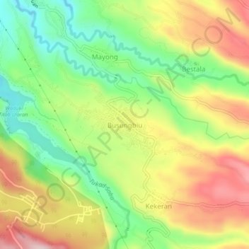
Name: Busungbiu topographic map, elevation, terrain.

Location: Busungbiu, Buleleng, Bali, Lesser Sunda Islands, Indonesia (-8.27536 114.94583 -8.23536 114.98583)

Average elevation: 251 m

Minimum elevation: 112 m

Maximum elevation: 412 m

Other topographic maps

Click on a map to view its topography, its elevation and its terrain.

Keberan

Indonesia > Bali > Buleleng

Average elevation: 275 m

Gerokgak

Indonesia > Bali > Buleleng

Average elevation: 197 m

Kubutambahan

Indonesia > Bali > Buleleng

Average elevation: 610 m

Gear up for your next adventure:

🐕Hiking Dog Pack - Let your canine companion carry their own water and food
🚲Handlebar Phone Mount - View topographic-map.com live while cycling
🧦Merino Wool Socks - Moisture-wicking comfort for long-distance hiking
🥾All-Terrain Hiking Boots - Versatile boots for varied hiking conditions
🪜Heavy Duty Carabiners - Multi-use clips for securing gear to your backpack

As an Amazon Associate, this site earns from qualifying purchases at no extra cost to you.