
Thank you for supporting this site ❤️
Make a donation
Make a donation
Gear up for your next adventure:
As an Amazon Associate, this site earns from qualifying purchases at no extra cost to you.
Kiarapedes topographic map
Click on the map to display elevation.
Thank you for supporting this site ❤️
Make a donation
Make a donation
Gear up for your next adventure:
As an Amazon Associate, this site earns from qualifying purchases at no extra cost to you.
About this map
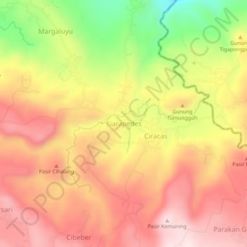
Name: Kiarapedes topographic map, elevation, terrain.
Location: Kiarapedes, Purwakarta, West Java, Java, 41175, Indonesia (-6.66676 107.55404 -6.62676 107.59404)
Average elevation: 502 m
Minimum elevation: 242 m
Maximum elevation: 673 m
Thank you for supporting this site ❤️
Make a donation
Make a donation
Gear up for your next adventure:
As an Amazon Associate, this site earns from qualifying purchases at no extra cost to you.