
Малага topographic map
Interactive map
Click on the map to display elevation.
About this map
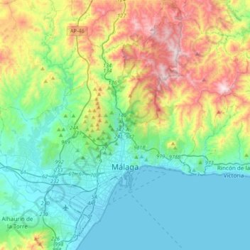
Name: Малага topographic map, elevation, terrain.
Location: Малага, Málaga-Costa del Sol, Málaga, Андалусия, Испания (36.63566 -4.58789 36.89404 -4.26049)
Average elevation: 276 m
Minimum elevation: -1 m
Maximum elevation: 1,019 m
Other topographic maps
Click on a map to view its topography, its elevation and its terrain.
Bailén-Miraflores
Испания > Андалусия > Málaga-Costa del Sol > Малага
Bailén-Miraflores, Малага, Málaga-Costa del Sol, Málaga, Андалусия, 29080, Испания
Average elevation: 79 m