
Thank you for supporting this site ❤️
Make a donation
Make a donation
Gear up for your next adventure:
As an Amazon Associate, this site earns from qualifying purchases at no extra cost to you.
Silveira topographic map
Click on the map to display elevation.
Thank you for supporting this site ❤️
Make a donation
Make a donation
Gear up for your next adventure:
As an Amazon Associate, this site earns from qualifying purchases at no extra cost to you.
About this map
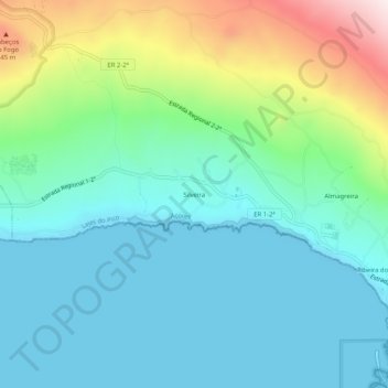
Name: Silveira topographic map, elevation, terrain.
Location: Silveira, Lajes do Pico, Açores, 9930-177, Portugal (38.39553 -28.30176 38.43553 -28.26176)
Average elevation: 150 m
Minimum elevation: 0 m
Maximum elevation: 614 m
Thank you for supporting this site ❤️
Make a donation
Make a donation
Gear up for your next adventure:
As an Amazon Associate, this site earns from qualifying purchases at no extra cost to you.