
Make a donation
Gear up for your next adventure:
As an Amazon Associate, this site earns from qualifying purchases at no extra cost to you.
Rauendahl topographic map
Click on the map to display elevation.
Make a donation
Gear up for your next adventure:
As an Amazon Associate, this site earns from qualifying purchases at no extra cost to you.
About this map
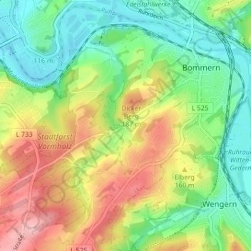
Name: Rauendahl topographic map, elevation, terrain.
Average elevation: 135 m
Minimum elevation: 72 m
Maximum elevation: 227 m
Make a donation
Gear up for your next adventure:
As an Amazon Associate, this site earns from qualifying purchases at no extra cost to you.
Other topographic maps
Click on a map to view its topography, its elevation and its terrain.
Bommern
Deutschland > Nordrhein-Westfalen > Ennepe-Ruhr-Kreis > Witten
Das S-Bahnzielnetz 2015 hatte ursprünglich vorgesehen, in Fahrtrichtung Witten hinter dem Haltepunkt Wetter (Ruhr) eine Ausfädelung zu bauen, damit die S-Bahnen auf der anderen Ruhrseite die reaktivierten Haltepunkte Wetter-Wengern Ost und Witten-Bommern Höhe bedienen. Wetter (Ruhr) wäre damit zum…
Average elevation: 125 m
Make a donation
Gear up for your next adventure:
As an Amazon Associate, this site earns from qualifying purchases at no extra cost to you.