Geolocate

Belpahar topographic map

Click on the map to display elevation.

About this map

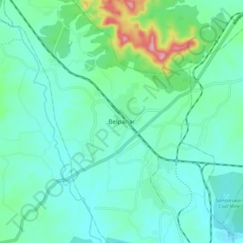
Name: Belpahar topographic map, elevation, terrain.

Location: Belpahar, Jharsuguda District, Odisha, 768217, India (21.78322 83.81070 21.86322 83.89070)

Average elevation: 236 m

Minimum elevation: 194 m

Maximum elevation: 412 m

Gear up for your next adventure:

👟Sport Hiking Sandals - Breathable footwear for water crossings and camp rest
🦟Insect Repellent - Keep mosquitoes and black flies away in wooded areas
🥾Mountain Hiking Boots - High-traction boots for rocky terrain
🩹Compact First Aid Kit - Pre-packed essentials for common trail injuries
🧢Beanie Hat - Keep your head warm in cold weather

As an Amazon Associate, this site earns from qualifying purchases at no extra cost to you.