
Make a donation
Gear up for your next adventure:
As an Amazon Associate, this site earns from qualifying purchases at no extra cost to you.
Quiruvilca topographic map
Click on the map to display elevation.
Make a donation
Gear up for your next adventure:
As an Amazon Associate, this site earns from qualifying purchases at no extra cost to you.
Quiruvilca
Abarca una superficie de 549,14 km² (kilómetros cuadrados), y tiene una población estimada mayor a 13 000 habitantes. Se encuentra a una altitud de aproximadamente 4000 m s. n. m. (metros sobre el nivel del mar).
Make a donation
Gear up for your next adventure:
As an Amazon Associate, this site earns from qualifying purchases at no extra cost to you.
About this map
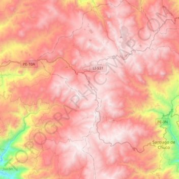
Name: Quiruvilca topographic map, elevation, terrain.
Location: Quiruvilca, Santiago de Chuco, La Libertad, Perú (-8.20785 -78.40615 -7.88122 -78.11728)
Average elevation: 3,642 m
Minimum elevation: 2,236 m
Maximum elevation: 4,313 m
Make a donation
Gear up for your next adventure:
As an Amazon Associate, this site earns from qualifying purchases at no extra cost to you.
Other topographic maps
Click on a map to view its topography, its elevation and its terrain.
Make a donation
Gear up for your next adventure:
As an Amazon Associate, this site earns from qualifying purchases at no extra cost to you.
Make a donation
Gear up for your next adventure:
As an Amazon Associate, this site earns from qualifying purchases at no extra cost to you.