
Ward 4 topographic map
Click on the map to display elevation.
About this map
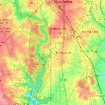
Name: Ward 4 topographic map, elevation, terrain.
Location: Ward 4, Washington, District of Columbia, United States (38.93509 -77.07174 38.99597 -76.99167)
Average elevation: 78 m
Minimum elevation: 19 m
Maximum elevation: 123 m
Other topographic maps
Click on a map to view its topography, its elevation and its terrain.
United States National Arboretum
United States > District of Columbia > Washington
Average elevation: 21 m
United States National Arboretum
United States > District of Columbia > Washington
Average elevation: 21 m