Geolocate

Hirschwang topographic map

Click on the map to display elevation.

About this map

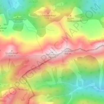
Name: Hirschwang topographic map, elevation, terrain.

Location: Hirschwang, Halblech, Landkreis Ostallgäu, Bayern, Deutschland (47.57871 10.88448 47.57881 10.88458)

Average elevation: 1,481 m

Minimum elevation: 1,102 m

Maximum elevation: 1,857 m

Gear up for your next adventure:

🥾Hiking Shorts - Breathable shorts suitable for summer hikes
🥾Mountain Hiking Shoes - Shoes with superior grip for mountainous terrain
🥾Waterproof Hiking Boots - Boots keeping your feet dry in wet conditions
🧢Outdoor Cap - Protective cap for sun and rain during hikes
🧥Waterproof Jacket - Lightweight rain jackets for hiking and outdoor activities

As an Amazon Associate, this site earns from qualifying purchases at no extra cost to you.