Geolocate

Gambrills topographic map

Click on the map to display elevation.

About this map

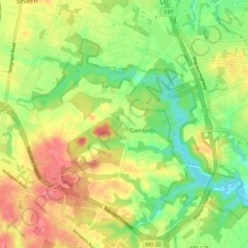
Name: Gambrills topographic map, elevation, terrain.

Location: Gambrills, Anne Arundel County, Maryland, United States (39.06486 -76.68556 39.12802 -76.62498)

Average elevation: 37 m

Minimum elevation: -1 m

Maximum elevation: 78 m

Gear up for your next adventure:

🚑Survival Whistle - Signal for help across long distances in mountains
🧣Merino Neck Gaiter - Protects against wind, sun, and cold at high altitudes
🥾Waterproof Hiking Shoes - Durable shoes for wet and rugged trails
💡Compact LED Flashlight - Powerful and portable flashlight for outdoor use
🧦Outdoor Socks - Durable socks designed for hiking and outdoor sports

As an Amazon Associate, this site earns from qualifying purchases at no extra cost to you.