
Saulnes topographic map
Interactive map
Click on the map to display elevation.
About this map
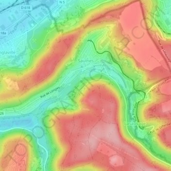
Name: Saulnes topographic map, elevation, terrain.
Average elevation: 338 m
Minimum elevation: 259 m
Maximum elevation: 409 m
Other topographic maps
Click on a map to view its topography, its elevation and its terrain.
Heillecourt
France > Grand Est > Meurthe-et-Moselle
Heillecourt, Nancy, Meurthe-et-Moselle, Grand Est, France métropolitaine, 54180, France
Average elevation: 236 m
Loisy
France > Grand Est > Meurthe-et-Moselle
Loisy, Nancy, Meurthe-et-Moselle, Grand Est, France métropolitaine, 54700, France
Average elevation: 218 m
Bréhain-la-Ville
France > Grand Est > Meurthe-et-Moselle
Bréhain-la-Ville, Val-de-Briey, Meurthe-et-Moselle, Grand Est, France métropolitaine, 54190, France
Average elevation: 407 m
Haraucourt
France > Grand Est > Meurthe-et-Moselle
Haraucourt, Nancy, Meurthe-et-Moselle, Grand Est, France métropolitaine, 54110, France
Average elevation: 250 m
Piennes
France > Grand Est > Meurthe-et-Moselle
Piennes, Val-de-Briey, Meurthe-et-Moselle, Grand Est, France métropolitaine, 54490, France
Average elevation: 302 m
Malzéville
France > Grand Est > Meurthe-et-Moselle
Malzéville, Nancy, Meurthe-et-Moselle, Grand Est, France métropolitaine, 54220, France
Average elevation: 258 m
Laxou
France > Grand Est > Meurthe-et-Moselle
Laxou, Nancy, Meurthe-et-Moselle, Grand Est, France métropolitaine, 54520, France
Average elevation: 280 m
Longlaville
France > Grand Est > Meurthe-et-Moselle
Longlaville, Briey, Meurthe-et-Moselle, Grand Est, France métropolitaine, 54810, France
Average elevation: 296 m
Vandœuvre-lès-Nancy
France > Grand Est > Meurthe-et-Moselle
Vandœuvre-lès-Nancy, Nancy, Meurthe-et-Moselle, Grand Est, France métropolitaine, 54500, France
Average elevation: 273 m
Courcelles
France > Grand Est > Meurthe-et-Moselle
Courcelles, Toul, Meurthe-et-Moselle, Grand Est, France métropolitaine, 54930, France
Average elevation: 338 m
Sivry
France > Grand Est > Meurthe-et-Moselle
Sivry, Nancy, Meurthe-et-Moselle, Grand Est, France métropolitaine, 54610, France
Average elevation: 297 m
Jarny
France > Grand Est > Meurthe-et-Moselle
Jarny, Val-de-Briey, Meurthe-et-Moselle, Grand Est, France métropolitaine, 54800, France
Average elevation: 208 m
Froidmont
France > Grand Est > Meurthe-et-Moselle > Champey-sur-Moselle
Froidmont, Champey-sur-Moselle, Nancy, Meurthe-et-Moselle, Grand Est, France métropolitaine, 54700, France
Average elevation: 290 m
Lunéville
France > Grand Est > Meurthe-et-Moselle
Lunéville, Meurthe-et-Moselle, Grand Est, France métropolitaine, 54300, France
Average elevation: 249 m
Moutiers
France > Grand Est > Meurthe-et-Moselle > Moutiers
Moutiers, Briey, Meurthe-et-Moselle, Grand Est, France métropolitaine, 54660, France
Average elevation: 239 m
Réhon
France > Grand Est > Meurthe-et-Moselle > Réhon
Réhon, Briey, Meurthe-et-Moselle, Grand Est, France métropolitaine, 54430, France
Average elevation: 325 m
Nancy
France > Grand Est > Meurthe-et-Moselle
Nancy, Meurthe-et-Moselle, Grand Est, France métropolitaine, France
Average elevation: 230 m