
Thank you for supporting this site ❤️
Make a donation
Make a donation
Gear up for your next adventure:
As an Amazon Associate, this site earns from qualifying purchases at no extra cost to you.
Ticatilín topographic map
Click on the map to display elevation.
Thank you for supporting this site ❤️
Make a donation
Make a donation
Gear up for your next adventure:
As an Amazon Associate, this site earns from qualifying purchases at no extra cost to you.
About this map
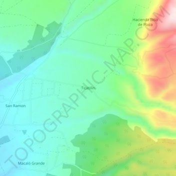
Name: Ticatilín topographic map, elevation, terrain.
Location: Ticatilín, Mulaló, Latacunga, Cotopaxi, Ecuador (-0.76836 -78.56639 -0.72836 -78.52639)
Average elevation: 3,197 m
Minimum elevation: 3,060 m
Maximum elevation: 3,525 m
Thank you for supporting this site ❤️
Make a donation
Make a donation
Gear up for your next adventure:
As an Amazon Associate, this site earns from qualifying purchases at no extra cost to you.