
Make a donation
Gear up for your next adventure:
As an Amazon Associate, this site earns from qualifying purchases at no extra cost to you.
Murs topographic map
Click on the map to display elevation.
Make a donation
Gear up for your next adventure:
As an Amazon Associate, this site earns from qualifying purchases at no extra cost to you.
About this map
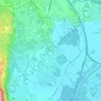
Name: Murs topographic map, elevation, terrain.
Average elevation: 288 m
Minimum elevation: 248 m
Maximum elevation: 521 m
Make a donation
Gear up for your next adventure:
As an Amazon Associate, this site earns from qualifying purchases at no extra cost to you.
Other topographic maps
Click on a map to view its topography, its elevation and its terrain.
Les Marches
France > Auvergne-Rhône-Alpes > Savoie > Porte-de-Savoie
Ce territoire, de 1 535 hectares, est situé entre 254 m et 1 134 m d’altitude. Son relief est caractérisé par trois types de formes naturelles, façonnées pendant le Quaternaire et la période historique.
Average elevation: 388 m
Les Marches
France > Auvergne-Rhône-Alpes > Savoie > Porte-de-Savoie
Ce territoire, de 1 535 hectares, est situé entre 254 m et 1 134 m d’altitude. Son relief est caractérisé par trois types de formes naturelles, façonnées pendant le Quaternaire et la période historique.
Average elevation: 388 m