
Make a donation
Gear up for your next adventure:
As an Amazon Associate, this site earns from qualifying purchases at no extra cost to you.
Walker topographic map
Click on the map to display elevation.
Make a donation
Gear up for your next adventure:
As an Amazon Associate, this site earns from qualifying purchases at no extra cost to you.
About this map
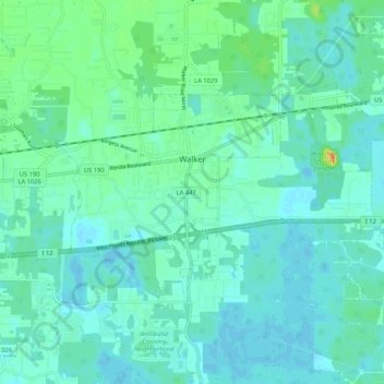
Name: Walker topographic map, elevation, terrain.
Location: Walker, Livingston Parish, Louisiana, United States (30.45407 -90.89881 30.50609 -90.79350)
Average elevation: 12 m
Minimum elevation: 4 m
Maximum elevation: 40 m
Make a donation
Gear up for your next adventure:
As an Amazon Associate, this site earns from qualifying purchases at no extra cost to you.
Other topographic maps
Click on a map to view its topography, its elevation and its terrain.
Make a donation
Gear up for your next adventure:
As an Amazon Associate, this site earns from qualifying purchases at no extra cost to you.
Magnolia Landing
United States > Louisiana > Livingston Parish > Magnolia Landing
Average elevation: 5 m