
Make a donation
Gear up for your next adventure:
As an Amazon Associate, this site earns from qualifying purchases at no extra cost to you.
Bad Gastein topographic map
Click on the map to display elevation.
Make a donation
Gear up for your next adventure:
As an Amazon Associate, this site earns from qualifying purchases at no extra cost to you.
Bad Gastein
Bad Gastein has a humid continental climate (Dfb) bordering on a subarctic climate (Dfc) due to the town's high elevation. Summers are mild, sometimes warm with cool, refreshing nights. Winters are moderately cold and snowy, with annual snowfall averaging 345 cm (136 inches).
Make a donation
Gear up for your next adventure:
As an Amazon Associate, this site earns from qualifying purchases at no extra cost to you.
About this map
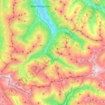
Name: Bad Gastein topographic map, elevation, terrain.
Location: Bad Gastein, Salzburg, 5640, Austria (47.01341 13.00051 47.16039 13.27731)
Average elevation: 1,929 m
Minimum elevation: 833 m
Maximum elevation: 3,191 m
Make a donation
Gear up for your next adventure:
As an Amazon Associate, this site earns from qualifying purchases at no extra cost to you.
Other topographic maps
Click on a map to view its topography, its elevation and its terrain.