Geolocate

Jatingarang topographic map

Click on the map to display elevation.

About this map

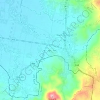
Name: Jatingarang topographic map, elevation, terrain.

Location: Jatingarang, Sukoharjo, Central Java, Java, 57562, Indonesia (-7.82576 110.74824 -7.78576 110.78824)

Average elevation: 141 m

Minimum elevation: 100 m

Maximum elevation: 319 m

Other topographic maps

Click on a map to view its topography, its elevation and its terrain.

Bulu

Indonesia > Central Java > Sukoharjo

Average elevation: 126 m

Puron

Indonesia > Central Java > Sukoharjo

Average elevation: 128 m

Lapangan Makamhaji

Indonesia > Central Java > Sukoharjo > Gentan > Kuyudan

Average elevation: 104 m

Waduk Mulur

Indonesia > Central Java > Sukoharjo > Bendosari

Average elevation: 114 m

Karangasem

Indonesia > Central Java > Sukoharjo > Karangasem

Average elevation: 115 m

Gear up for your next adventure:

🧊Portable Cooler - Keep food and drinks cold during outdoor adventures
🦯Trekking Poles - Reduced impact on joints for steep topographic climbs
🌡️Emergency Mylar Blankets - Compact thermal protection for unexpected nights outdoors
🍽️Titanium Camping Spork - Ultralight and indestructible eating utensil
🧴Insect Repellent - Protect yourself from bugs during outdoor adventures

As an Amazon Associate, this site earns from qualifying purchases at no extra cost to you.