Geolocate

Acho topographic map

Click on the map to display elevation.

About this map

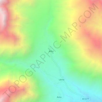
Name: Acho topographic map, elevation, terrain.

Location: Acho, Ayo, Castilla, Arequipa, Perú (-15.67476 -72.32629 -15.63476 -72.28629)

Average elevation: 2,784 m

Minimum elevation: 2,115 m

Maximum elevation: 3,731 m

Gear up for your next adventure:

🚲Handlebar Phone Mount - View topographic-map.com live while cycling
🧥Softshell Hiking Jacket - The perfect balance of wind protection and breathability
🧦Hiking Liner Socks - Thin base layer to prevent friction and blisters
🛰️Satellite Messenger - Emergency communication for areas with no cell service
🧭GPS Tracker - Track your location in remote areas safely

As an Amazon Associate, this site earns from qualifying purchases at no extra cost to you.