Geolocate

Keytodac topographic map

Click on the map to display elevation.

About this map

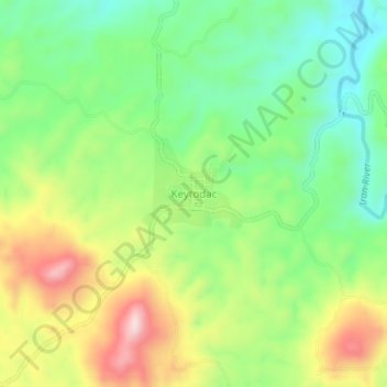
Name: Keytodac topographic map, elevation, terrain.

Location: Keytodac, Sultan Kudarat, 9807, Philippines (6.64598 124.24176 6.68598 124.28176)

Average elevation: 642 m

Minimum elevation: 504 m

Maximum elevation: 849 m

Other topographic maps

Click on a map to view its topography, its elevation and its terrain.

Kabulnan River

Philippines > Sultan Kudarat

Average elevation: 591 m

Columbio

Philippines > Sultan Kudarat

Average elevation: 268 m

Lutayan

Philippines > Sultan Kudarat

Average elevation: 73 m

Kapingkong River

Philippines > Sultan Kudarat > Sampao

Average elevation: 61 m

Gear up for your next adventure:

🧥Softshell Hiking Jacket - The perfect balance of wind protection and breathability
🔭Compact Monocular - One-handed bird watching and trail spotting
🧥Packable Rain Jacket - Breathable waterproof layer for unpredictable weather
🧦Crew Hiking Socks - Comfortable socks for long-distance hikes
🗺️Topographic Maps - Detailed maps to explore trails, mountains, and wilderness areas

As an Amazon Associate, this site earns from qualifying purchases at no extra cost to you.