
Kobylnica topographic map
Interactive map
Click on the map to display elevation.
About this map
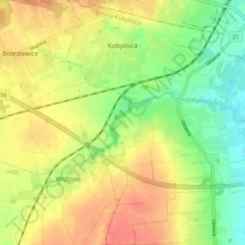
Name: Kobylnica topographic map, elevation, terrain.
Average elevation: 45 m
Minimum elevation: 21 m
Maximum elevation: 65 m
Other topographic maps
Click on a map to view its topography, its elevation and its terrain.
Główczyce
Poland > Pomeranian Voivodeship > Słupsk County
Główczyce, gmina Główczyce, Słupsk County, Pomeranian Voivodeship, 76-220, Poland
Average elevation: 27 m
Ustka
Poland > Pomeranian Voivodeship > Słupsk County > Ustka
Ustka, Słupsk County, Pomeranian Voivodeship, Poland
Average elevation: 6 m
Kępice
Poland > Pomeranian Voivodeship > Słupsk County
Kępice, gmina Kępice, Słupsk County, Pomeranian Voivodeship, Poland
Average elevation: 67 m
Warcino
Poland > Pomeranian Voivodeship > Słupsk County
Warcino, gmina Kępice, Słupsk County, Pomeranian Voivodeship, 77-230, Poland
Average elevation: 83 m
Barcino
Poland > Pomeranian Voivodeship > Słupsk County
Barcino, gmina Kępice, Słupsk County, Pomeranian Voivodeship, 77-232, Poland
Average elevation: 78 m