
Make a donation
Gear up for your next adventure:
As an Amazon Associate, this site earns from qualifying purchases at no extra cost to you.
Damián Carmona topographic map
Click on the map to display elevation.
Make a donation
Gear up for your next adventure:
As an Amazon Associate, this site earns from qualifying purchases at no extra cost to you.
About this map
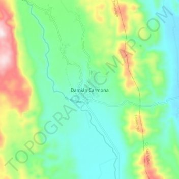
Name: Damián Carmona topographic map, elevation, terrain.
Location: Damián Carmona, Tamasopo, San Luis Potosí, Mexico (22.05733 -99.33137 22.13733 -99.25137)
Average elevation: 451 m
Minimum elevation: 282 m
Maximum elevation: 855 m
Make a donation
Gear up for your next adventure:
As an Amazon Associate, this site earns from qualifying purchases at no extra cost to you.
Other topographic maps
Click on a map to view its topography, its elevation and its terrain.
Charcas
Charcas is a town and municipality in the Mexican state of San Luis Potosí. The municipality covers an area of 4.911 km2. As of 2020, the municipality had a total population of 14,117 people. Charcas is just south of the Tropic of Cancer. Due to its elevation of 2,219 metres (7,280 ft), the climate is mild.
Average elevation: 2,119 m
Make a donation
Gear up for your next adventure:
As an Amazon Associate, this site earns from qualifying purchases at no extra cost to you.
Make a donation
Gear up for your next adventure:
As an Amazon Associate, this site earns from qualifying purchases at no extra cost to you.
Villa de Ramos
The municipality is located to the northwest in the state of San Luis, in the altiplano region. The municipal head or capital, has the following coordinates: 101*55' West longitude and 22*50' North latitude, with an elevation of 2,200 meters above sea level. Villa de Ramos is bordered by Santo Domingo to the…
Average elevation: 2,092 m
Make a donation
Gear up for your next adventure:
As an Amazon Associate, this site earns from qualifying purchases at no extra cost to you.
El Naranjo
El Naranjo is located in an extensive area of tropical and semi-tropical mountains and lowlands called La Huasteca after the Indian civilization and people inhabiting the region. The town of El Naranjo is in the foothills of the Sierra Madre Oriental. It received its name because previously an orchard of…
Average elevation: 733 m
Make a donation
Gear up for your next adventure:
As an Amazon Associate, this site earns from qualifying purchases at no extra cost to you.
Make a donation
Gear up for your next adventure:
As an Amazon Associate, this site earns from qualifying purchases at no extra cost to you.
Make a donation
Gear up for your next adventure:
As an Amazon Associate, this site earns from qualifying purchases at no extra cost to you.