Geolocate

Alpine topographic map

Click on the map to display elevation.

About this map

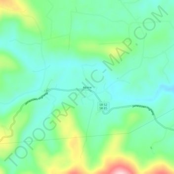
Name: Alpine topographic map, elevation, terrain.

Location: Alpine, Overton County, Middle Tennessee, Tennessee, United States (36.37479 -85.23691 36.41479 -85.19691)

Average elevation: 311 m

Minimum elevation: 243 m

Maximum elevation: 485 m

Other topographic maps

Click on a map to view its topography, its elevation and its terrain.

Livingston

United States > Tennessee > Overton County

According to the United States Census Bureau, the town has a total area of 5.2 square miles (13 km2), of which 5.1 square miles (13 km2) is land and 0.04 square miles (0.10 km2) (0.77%) is water. Elevation in the town ranges from 1,027 ft (313 m) to 1700 ft (518.16 m)

Average elevation: 349 m

Gear up for your next adventure:

🥾All-Terrain Hiking Boots - Versatile boots for varied hiking conditions
🧭GPS Handheld Device - Reliable GPS navigation for outdoor adventures
🔥Emergency Fire Starter - Reliable ignition source for all weather conditions
🕶️Polarized Sunglasses - Reduces glare from snow and water at high elevations
👟Trail Running Shoes - Agile footwear for fast-paced topographic exploration

As an Amazon Associate, this site earns from qualifying purchases at no extra cost to you.