
Thank you for supporting this site ❤️
Make a donation
Make a donation
Gear up for your next adventure:
As an Amazon Associate, this site earns from qualifying purchases at no extra cost to you.
Meckenbeuren topographic map
Click on the map to display elevation.
Thank you for supporting this site ❤️
Make a donation
Make a donation
Gear up for your next adventure:
As an Amazon Associate, this site earns from qualifying purchases at no extra cost to you.
About this map
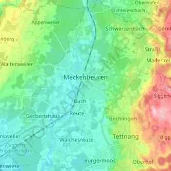
Name: Meckenbeuren topographic map, elevation, terrain.
Location: Meckenbeuren, Bodenseekreis, Baden-Württemberg, 88074, Germany (47.65492 9.51333 47.73665 9.62753)
Average elevation: 451 m
Minimum elevation: 400 m
Maximum elevation: 586 m
Thank you for supporting this site ❤️
Make a donation
Make a donation
Gear up for your next adventure:
As an Amazon Associate, this site earns from qualifying purchases at no extra cost to you.