Geolocate

Whiteriver topographic map

Click on the map to display elevation.

About this map

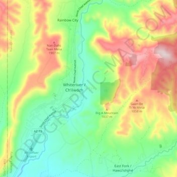
Name: Whiteriver topographic map, elevation, terrain.

Location: Whiteriver, Navajo County, Arizona, 85941, United States (33.79634 -109.99852 33.87662 -109.91923)

Average elevation: 1,708 m

Minimum elevation: 1,513 m

Maximum elevation: 2,004 m

Other topographic maps

Click on a map to view its topography, its elevation and its terrain.

Big A Mountain

United States > Arizona > Navajo County > Whiteriver

Average elevation: 1,693 m

Gear up for your next adventure:

🔥Camping Stove - Portable stoves to cook outdoors with ease
🧳Compression Sacks - Maximize space in your backpack by shrinking gear
❄️Traction Ice Cleats - Slip-on spikes for icy trails and winter hiking
🧥Waterproof Jacket - Lightweight rain jackets for hiking and outdoor activities
💡Portable Camping Lamp - Rechargeable lamp for campsite lighting

As an Amazon Associate, this site earns from qualifying purchases at no extra cost to you.